Visiting Washington's Volcanoes
- Vicky
- Feb 22, 2023
- 4 min read
Updated: Mar 1, 2023
While on vacation in Washington State, Amber, Michael, and I visited two volcanoes located in the Cascade Mountain Range.
Mount Rainier
Mount Rainier National Park is home of the active volcano and the most glaciated peak in the contiguous United States. Ascending to 14,410 feet, Mount Rainier can be seen from quite a distance in Washington State.
On our vacation in September 2022 to Washington, we visited this volcano. We were going to go to Reflection Lake to get the most iconic views of Mount Rainier.

On our way towards this view, we passed Christine Falls. Christine Falls is quite pretty, and the most easily accessible falls located in the national park. Besides the impressive view of the falls, the lower falls is framed by the historic arching Christine Falls Bridge. In total the falls drop 69 feet with the upper section being 32 feet and lower section 37 feet, which is nearly impossible to photograph together.

We made our way to Paradise, the name of the area that is about 5,400 feet on the south slope of Mount Rainier. We had impressive views of the fall colors on the subalpine meadow. However, the clouds were blocking the views of the mountain. After stopping by Henry M Jackson Memorial Visitor Center, we hopped in the car to continue.
We parked in the parking lot close to Reflection Lake and did a short walk over to the water’s edge. While the mountain was hidden from view by the clouds it was a very restful place. As we enjoyed the scenery the clouds broke partly, and we were able to see part of Mount Rainier.
We headed on our way towards Seattle, stopping at a few of the overlooks to see the impressive mountain range surrounding the area.
Mount St. Helens
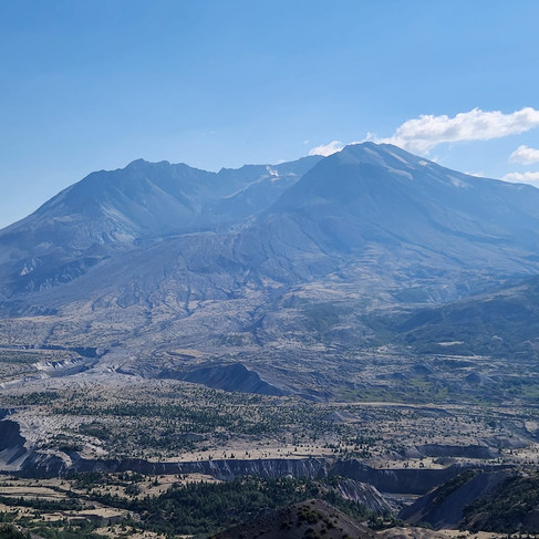
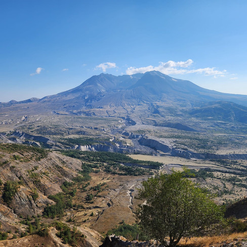
Mount St. Helens National Volcanic Monument has its home in the Cascade Range in southwestern Washington State. It is most known for one of the greatest volcanic explosions ever to be recorded in North America. Originally ascending to 9,677 feet, which made it the fifth highest peak in Washington State, the May 18, 1980, explosion brought the elevation down to 8,365 feet.
We first stopped at the visitor center which is located over 45 miles from the mountain. At the visitor center we watched a short video about the area, then explored local history, geology of volcanoes, chronological timeline of the events leading up to the blast and walked into a model of a volcano. Mount St. Helens name was given by explorer Captain George Vancouver in honor of friend the Baron St. Helens, Alleyne Fizherbert. From the visitor center you should be able to see views of the volcano however it was cloudy. I was worried that this would be a repeat of Mount Rainier so looked over at the live feed video from Johnston Ridge Observatory, our next stop, and the view appeared to be cleared.

We stopped at the Forest Learning Center for a quick stop and view of the valley below. This center is located just inside the blast zone. While viewing the valley below, we were informed that underneath the ground about 30 feet was the old highway. All the trees we were viewing were hand planted to recover the area after the volcano cleared them away.

As we drove on it was impressive as the dense new forest turned into rocky ground. It was quite the drastic change. Once we arrived at the Johnston Ridge Observatory, it looked like we stepped onto another plant. We went inside the observatory which also had a video that showed the drastic change in the landscape from the observatory. In the exhibits there were also human stories of their experiences during the explosion.
One section that Michael and I found quite amusing was about historic eruptions that scientist didn’t understand why such formations were found in various other blast areas. However, with the blast from Mount St. Helens they were able to be understand why and how such formations were found and that what happened at Mount St. Helens had happened to various other volcanoes around the world.

Amber, Michael, and I had learned in school about Mount St. Helens’ explosion in the early 1980s, but it was the experience to see the area afterwards firsthand that really left an impression. When learning the chronological order of events that started on March 27, 1980, with an explosive steam eruption from Mount St. Helens. The volcano would later experience minor eruptions and earthquakes with growing pressure causing a bulge to form on the north side of the peak. Then on the morning of May 18, a massive earthquake would trigger a landslide down the north side of the peak. This avalanche would then be overtaken by a lateral air blast, which had superheated ash and stone. The avalanche and blast were followed by mudflows (some which made it over the rolling hills and to where we had stood on Johnston Ridge Observatory), pyroclastic flows, floods from the melted glaciers on Mount St. Helens. Because of this explosion Mount St. Helens peak was completely blasted away leaving the horseshoe-shaped crater. Also, we learned that even some new lakes were formed because of the explosion.
We walked to the viewing area, and you could see steam coming up to form a new forming cone. It was quite the sight, seeing all the changes to landscape and that we were viewing how these changes are still evident in the landscape from over 40 years ago.
As we headed to Seattle after viewing Mount St. Helens and reminiscing about the views from Mount Rainier. It was quite the shock to realize that the area around Mount St. Helens used to look very similar to that of Mount Rainier.


Comments